![](/images/other/stat-length.png)
![Trail Walking La Grave - LES HIÈRES (13 KM - D. 1043 M) - Photo](https://media.geolcdn.com/t/1900/400/ext.pjpeg?maxdim=2&url=https%3A%2F%2Fstatic1.geolcdn.com%2Fsiteimages%2Fupload%2Ffiles%2F1553511878bg_sport_marche.png)
LES HIÈRES (13 KM - D. 1043 M)
Thomasdanielle
User
![Length](/images/other/stat-length.png)
Length
12.8 km
![Max alt](https://static1.geolcdn.com/siteimages/upload/files/1508320355ic_sort_altitude_max_24dp.png)
Max alt
2745 m
![Uphill gradient](https://static1.geolcdn.com/siteimages/upload/files/1508320355ic_sort_den_pos_24dp.png)
Uphill gradient
1043 m
![Km-Effort](/images/other/stat-length.png)
Km-Effort
27 km
![Min alt](https://static1.geolcdn.com/siteimages/upload/files/1508320355ic_sort_altitude_min_24dp.png)
Min alt
1761 m
![Downhill gradient](https://static1.geolcdn.com/siteimages/upload/files/1508320355ic_sort_den_neg_24dp.png)
Downhill gradient
1042 m
![Boucle](https://static1.geolcdn.com/siteimages/upload/files/16400158638029165_repeat_loop_refresh_sync_direction_icon.png)
Boucle
Yes
Creation date :
2019-05-29 14:19:54.63
Updated on :
2019-05-29 14:26:27.001
![Walking](https://static1.geolcdn.com/sitytour/trail-icons/101.png)
5h16
Difficulty : Very difficult
![Scan this QR Code to open this trail in the SityTrail application](https://capi.geolives.com/qq0zvz2zws4bq2lad0pu/sitytour/trails/2097705/qr.png?size=200)
FREE GPS app for hiking
About
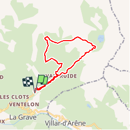
Trail Walking of 12.8 km to be discovered at Provence-Alpes-Côte d'Azur, Hautes-Alpes, La Grave. This trail is proposed by Thomasdanielle.
Description
D/A : Les Hières - Hameau de Valfroide - Avant d'arriver au Lac du Goléon au point Berg tourner à gauche suivre la roche de Casse puis aller en direction du Chalet du Puy Granier, continuer jusqu'à la Saulce puis rejoindre la descente retour vers les Hières.
Positioning
Country:
France
Region :
Provence-Alpes-Côte d'Azur
Department/Province :
Hautes-Alpes
Municipality :
La Grave
Location:
Unknown
Start:(Dec)
Start:(UTM)
288649 ; 4992884 (32T) N.
Comments
Trails nearby
![Trail Walking Villar-d'Arêne - L'Aiguillon et Lac du Pontet 28.8.22 - Photo](https://media.geolcdn.com/t/375/260/007e50a5-b3c9-4529-9bf1-1ab760d39579.jpg&format=jpg&maxdim=2)
![Walking Walking](https://static1.geolcdn.com/sitytour/trail-icons/101.png)
L'Aiguillon et Lac du Pontet 28.8.22
Walking
Very easy
(1)
Villar-d'Arêne,
Provence-Alpes-Côte d'Azur,
Hautes-Alpes,
France
![](/images/other/stat-length.png)
6 km | 9.4 km-effort
2h 0min
![](https://static1.geolcdn.com/siteimages/upload/files/16400158638029165_repeat_loop_refresh_sync_direction_icon.png)
Yes
![Trail Walking La Grave - L'aiguille du Goléon - Photo](https://media.geolcdn.com/t/375/260/ext.jpg?maxdim=2&url=https%3A%2F%2Fservices.sitytrail.com%2FGeolivesWS%2FDownloadMedia.ashx%3FTrailID%3D101222%26Media%3D710_2.jpg)
![Walking Walking](https://static1.geolcdn.com/sitytour/trail-icons/101.png)
L'aiguille du Goléon
Walking
Very difficult
(1)
La Grave,
Provence-Alpes-Côte d'Azur,
Hautes-Alpes,
France
![](/images/other/stat-length.png)
9.1 km | 25 km-effort
5h 0min
![](https://static1.geolcdn.com/siteimages/upload/files/16400158638029165_repeat_loop_refresh_sync_direction_icon.png)
No
![Trail Walking La Grave - 05 lac goleon - Photo](https://media.geolcdn.com/t/375/260/abf8f99e-f4a4-42bd-8090-69a0a4a7cd63.jpg&format=jpg&maxdim=2)
![Walking Walking](https://static1.geolcdn.com/sitytour/trail-icons/101.png)
05 lac goleon
Walking
Medium
La Grave,
Provence-Alpes-Côte d'Azur,
Hautes-Alpes,
France
![](/images/other/stat-length.png)
14.4 km | 28 km-effort
6h 2min
![](https://static1.geolcdn.com/siteimages/upload/files/16400158638029165_repeat_loop_refresh_sync_direction_icon.png)
Yes
![Trail Walking La Grave - 05 refuge e chancel - Photo](https://media.geolcdn.com/t/375/260/e45ae6e7-d20c-4652-ac11-0baa8b6d8886.jpg&format=jpg&maxdim=2)
![Walking Walking](https://static1.geolcdn.com/sitytour/trail-icons/101.png)
05 refuge e chancel
Walking
Medium
La Grave,
Provence-Alpes-Côte d'Azur,
Hautes-Alpes,
France
![](/images/other/stat-length.png)
11.4 km | 25 km-effort
7h 19min
![](https://static1.geolcdn.com/siteimages/upload/files/16400158638029165_repeat_loop_refresh_sync_direction_icon.png)
No
![Trail Walking La Grave - vallons de la Meije : lac Puy Vachère - Photo](https://media.geolcdn.com/t/375/260/67d29b46-abdb-45ba-9c3a-55e84b743ed6.jpg&format=jpg&maxdim=2)
![Walking Walking](https://static1.geolcdn.com/sitytour/trail-icons/101.png)
vallons de la Meije : lac Puy Vachère
Walking
Very difficult
La Grave,
Provence-Alpes-Côte d'Azur,
Hautes-Alpes,
France
![](/images/other/stat-length.png)
12.7 km | 27 km-effort
5h 44min
![](https://static1.geolcdn.com/siteimages/upload/files/16400158638029165_repeat_loop_refresh_sync_direction_icon.png)
Yes
![Trail Walking Villar-d'Arêne - Lac d'Arsine - Photo](https://media.geolcdn.com/t/375/260/e7f87057-c742-4181-83c9-59ebf50a12c8.jpg&format=jpg&maxdim=2)
![Walking Walking](https://static1.geolcdn.com/sitytour/trail-icons/101.png)
Lac d'Arsine
Walking
Difficult
Villar-d'Arêne,
Provence-Alpes-Côte d'Azur,
Hautes-Alpes,
France
![](/images/other/stat-length.png)
17.2 km | 28 km-effort
5h 37min
![](https://static1.geolcdn.com/siteimages/upload/files/16400158638029165_repeat_loop_refresh_sync_direction_icon.png)
Yes
![Trail On foot La Grave - Le Chazelet - Refuge du Pic du Mas de la Grave en boucle - Photo](https://media.geolcdn.com/t/375/260/52a9a626-d23a-47b8-b762-a5eff72b3bed.jpg&format=jpg&maxdim=2)
![On foot On foot](https://static1.geolcdn.com/sitytour/trail-icons/100.png)
Le Chazelet - Refuge du Pic du Mas de la Grave en boucle
On foot
Easy
La Grave,
Provence-Alpes-Côte d'Azur,
Hautes-Alpes,
France
![](/images/other/stat-length.png)
9.8 km | 14.4 km-effort
3h 16min
![](https://static1.geolcdn.com/siteimages/upload/files/16400158638029165_repeat_loop_refresh_sync_direction_icon.png)
Yes
![Trail Walking Villar-d'Arêne - SityTrail - Lac du pontet et l'Aiguillon - Photo](https://media.geolcdn.com/t/375/260/ext.jpg?maxdim=2&url=https%3A%2F%2Fstatic1.geolcdn.com%2Fsiteimages%2Fupload%2Ffiles%2F1553511878bg_sport_marche.png)
![Walking Walking](https://static1.geolcdn.com/sitytour/trail-icons/101.png)
SityTrail - Lac du pontet et l'Aiguillon
Walking
Medium
(1)
Villar-d'Arêne,
Provence-Alpes-Côte d'Azur,
Hautes-Alpes,
France
![](/images/other/stat-length.png)
5.2 km | 8.6 km-effort
1h 56min
![](https://static1.geolcdn.com/siteimages/upload/files/16400158638029165_repeat_loop_refresh_sync_direction_icon.png)
Yes
![Trail Walking La Grave - 2020-09-03 Marche Tour de la Grave au plateau d'Emparis par le Pic du Mas de la Grave (3 jours) - Photo](https://media.geolcdn.com/t/375/260/db3fb938-b4cb-4c23-b152-eb22bce76ff5.jpg&format=jpg&maxdim=2)
![Walking Walking](https://static1.geolcdn.com/sitytour/trail-icons/101.png)
2020-09-03 Marche Tour de la Grave au plateau d'Emparis par le Pic du Mas de ...
Walking
Medium
La Grave,
Provence-Alpes-Côte d'Azur,
Hautes-Alpes,
France
![](/images/other/stat-length.png)
51 km | 88 km-effort
17h 56min
![](https://static1.geolcdn.com/siteimages/upload/files/16400158638029165_repeat_loop_refresh_sync_direction_icon.png)
No